40 Years of Radar Science
In 2010, and with decades of experience behind us and a knack for developing sophisticated processing algorithms, we got to work building our first commercial radar.
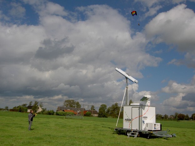
We set out with aviation, civil, and military in mind, aiming for a 3D system to empower bird control teams with a greater awareness of their airspace. FIXED/FLEX would get us close.
We already had a prototype of the FLEX system, but there are snags. Cable constraints prevented it from continuous rotation, namely due to the electronics box mounted between the antennas. We needed a redesign, but that would take time.
“There were already customers waiting on systems, so we decided to speed up production by inventing FIXED,” explains Robin Radar System Specialist, Wouter Keijer. "Introducing FIXED bridged the gap between our market goals and a lengthy redesign. It formed an intermediate version of a 3D radar by combining the two different systems."
"FIXED is two pulse radars on static mounts, FLEX is one pulse radar and one FMCW on a rotating mount, giving 360° coverage. Effectively, a set of spinning sensors that delivered overlapping coverage.”
“FLEX needed some work, though. It could only complete one scan, then another in the reverse direction. It took some time before we landed on an engineering update that eventually got us over the line. This was the most challenging task.
"We also had to get the horizontal radar up and running, select the proper hardware for a commercial installation and develop a user interface and database for our customer.
“It was tough, but it laid much of the groundwork for all of our systems, which inherited and developed traits from FIXED and FLEX. Much of the software architecture and significant parts of the high-frequency electronics in the sensor are still recognisable today.”


In 2014, we began simultaneously innovating for another emerging threat: drones.
We saw drone use advancing, and their availability and commercialisation were becoming an increasing risk. Our technologies held the potential to help, so we went bac k to the drawing board.
We already knew our radars could detect drones because we used them in continuous testing and validation cycles. But, could we build a radar that distinguishes them from birds, classifies them accurately, and tracks their erratic flight? There was only one way to find out!
We challenged ourselves to innovate ELVIRA, our 2D drone radar, fast. Really fast. Wouter said: “We wanted to get a robust and capable CUAS radar to market as soon as possible. That meant reusing a lot of the components from our avian radar, and COTS parts for the rest."
“We began with one of the main differentiating components of the radar: the Doppler signature. This is how ELVIRA can classify drones, with micro-doppler technology that distinguishes them from birds and other flying objects. It was the main challenge for us, as it was completely new."
“Our design principles centred around simplicity. We wanted to bring something capable and affordable, aiming for a rotating radar that achieved low power usage, and doppler capability, with our FMCW technology.”
By 2015, and thanks to the tireless efforts of our engineering teams, we were ready.
Amazingly, within a year of beginning the project, our specialised 2D radar landed in the defence and security market.
As 2013 dawned, it was time for our next-generation avian radar. With it, we were determined to revolutionise bird detection by combining 3D technologies with 360° awareness. We also wanted to build in logging and reporting tools to make data sing for bird control teams, wind farm operators, and ecological experts alike.
Engineering teams focused on achieving a high update rate, a longer range, and more elevation coverage with a smaller cone of silence. Not to mention, the key ingredient of altitude measurement for full 3D awareness.
“That was tricky,” explains Wouter, “because the probability of a target's successful detection rests on the average amount of energy striking it, and for how long. A pulse radar emits a very high pulse of energy, but for a short time, which isn't ideal. But by now, we’d established our core FMCW technology, which stretches time spent on a target and reduces output power."
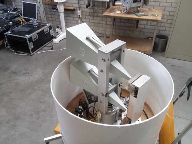
“We added phased array technology to achieve 3D, this involves an array of small antennas that steer beams electronically. They work together, sending and receiving radio waves simultaneously and in a carefully controlled and timed way."
“This combination makes MAX unique, to this day. The market is mostly comprised of static panel radars with phased array technology. That makes them expensive, and achieving 360° coverage takes more than one. In MAX, and later, IRIS, we took a fresh approach by merging the idea of traditional rotating radar, for 360° coverage, with phased array technology in one direction, for altitude (full 3D). This reduces component costs and keeps the radar more affordable."
“Because we didn’t compromise on these initial design principles, we had to do a lot of troubleshooting and alternative thinking. We began with the antenna design, a modular system with highly integrated electronics. It was a lot of work, but resulted in a highly innovative patent that connected the electronics boards to the antenna."
“We also gave careful consideration to MAX’s data processing. 48 channels of 15 MHz raw data feed into the processing module, so we needed high-speed signal processing on a big Field Programmable Gate Array (FPGA). That was a real challenge.”
In 2017, years of hard work paid off, and we unveiled MAX to the world. Today, it sits in a market-leading position, offering 3D, 360° coverage, a lightning-fast scan speed of just 1 second, an instrumented range of 15 km, and an extensive database and logging tools.

-1.jpg?width=1839&height=2754&name=RRS%20IRIS%20OTM-2%20(1)-1.jpg)
Fast forward three years to 2018. Robin is still the same innovative technology company revolutionising radar, but the world is changing. In December of that year, the impact of drone disruption was immortalised in an incident that grounded over 1,000 flights at Gatwick Airport in the UK.
Approximately 140,000 passengers were affected as operations ground to a halt following reports of a drone sighting. This incident cost the aviation industry an estimated £70 million, underscoring the need for stricter regulations and counter-drone technologies.
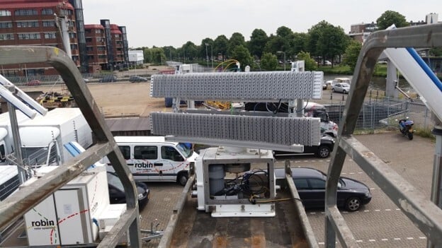
Thankfully, we’d already got to work innovating our next CUAS radar: IRIS. This one would be small, deployable; a radar that wouldn't compromise in any aspect of deployment, detection or classification.
Wouter explains: “We aimed for an update rate equal to or better than that of ELVIRA. We also wanted more elevation coverage and a smaller cone of silence. The largest differentiator between ELVIRA and IRIS would be the fact that this was a 3D radar, rather than 2D, meaning it could provide accurate altitude as well as 360° coverage."
“Although its form and function were different, we saw IRIS almost like a mini-MAX. Both are 3D radars using phased array technology, one innovated for birds, the other drones. So, we began by checking which parts we could reuse."
“Unlike MAX, though, IRIS also needed doppler capability. That made things a little more complex.”
For the radar to classify a target with Doppler, it needs to spend time on it to analyse and process it. However, the longer the radar spends on a target, the longer the track update rate, which degrades real-time detection.
Wouter said: “We didn’t want to compromise our one-second update rate, but the solution came in the form of our unique back-to-back antenna concept. That increases the update rate without losing doppler capability."
“In the wake of our success with FMCW technology, we once again applied it in IRIS. We also introduced a phased array technology for the altitude measurement, just like MAX."
“In IRIS, we wanted to bring all of these capabilities together in a small, lightweight design. That was difficult, we had to go through a lot of iterations to balance the signal generator with the Doppler signature, the digital beam with the processing computer, and the list goes on."
“We also had to factor in military specifications on temperature, shock and vibration, and electromagnetic emissions. That’s difficult when working with a highly restricted size and weight design. But we knew that’s what the market needed.”
It was a balancing act that took two years of careful give and take. We launched IRIS in 2020; the drone radar that didn’t compromise.