Spot drone threats before they escalate. IRIS combines micro-doppler classification, deep neural network (DNN) technology, and on-the-move (OTM) capability for 360°, 3D coverage in one small but mighty package.


.png)
Considering counter-uas radar?
Managing drone threats with speed and precision takes a system of sensors. We focus on detection, building each counter-UAS radar to sit at the heart of your network. With state-of-the-art hardware and software, our radars deliver early warnings and reliable intelligence. They’re lightweight, made to integrate, and adapt to your needs and setup.

360° coverage in 3D
Combining 360° views, 60° elevation, and a 5 km (3.1 miles) instrumented range, IRIS gives you a huge 78 km² (30.1 mi2) coverage area. That’s a full grasp of what’s happening all around you, all year round.
Classify with conviction
Micro-doppler classification and DNN technology mean IRIS can distinguish blades and rotating parts. IRIS isn’t phased by birds and detects fixed-wing and hovering drones.

Intuitive interface
When every second counts, you can't afford delays. With an intuitive, interoperable user interface, IRIS gives you easy access to real-time tracking data for fast and effective responses to drone threats.
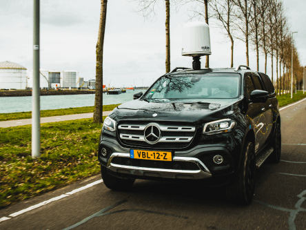
Radar on the move
Travel with your target using our on-the-move (OTM) feature. Mounted to a vehicle or maritime vessel, IRIS detects, tracks, and classifies drones while travelling at speed. On land up to 100 km/h (62 mph).
Made for accuracy
IRIS combines durable hardware with smart software for reliable 3D detection. Micro-doppler and DNN technology distinguish blades, and IRIS pairs 360° coverage with accurate height information to cue other sensors and countermeasures seamlessly.
- Micro-doppler classification
- 3D accurate height information
- Tested and certified against military environmental standards
- ISO 27001 and ISO 9001 compliant


Small, lightweight, built to integrate
Deployment takes less than 15 minutes, giving your team quick, actionable insights. Easily mount IRIS on buildings and tripods for fixed operations, or deploy it on vehicles and maritime vessels to deliver on-the-move intel at speed.
- Lightweight and deployable: 29 kg (64 lb)
- Compact footprint: 550 mm x 630 mm (22" x 25")
- OTM capable on land and at sea
- Integration-ready API (including C2)
Please contact us for further information on maritime operations.
Long-Range Mode (LRM)
Every extra kilometre of detection buys time to assess and react. IRIS LRM is a leap in performance, delivered through code alone.
- Switch between 5km and 12km instrumented ranges in minutes
- Detect and classify loitering munitions and Fixed Wing drones at long distances.
- Innovated and battle-tested on frontlines.


IRIS will support counter-UAS operations at the FIFA World Cup 2026.
Our 3D drone detection radar will be deployed by components of the U.S. Department of Homeland Security (DHS), alongside state and local agencies, to secure skies at the FIFA World Cup in North America later this year.

Dutch Ministry of Defence orders 100 IRIS radars
A major contract with the Dutch Ministry of Defence (MoD) to supply 100 flagship IRIS drone-detection radars marks our largest contract yet. It also demonstrates one of Europe’s largest investments in drone-detection sensing to date. There’s a glaring need for fast innovation cycles and increased national airspace protection in NATO countries. And beyond.
Level up your radar with our IRIS add-ons
Detect on the move
Put your radar on the move with our OTM module. Mount on convoys or vehicles to detect, track and classify at speeds of up to 100 km/h (60 mph).

Customise colour
Customise your IRIS radome to suit your operational needs. Our bespoke colour palette includes white, bronze green, sand beige, or brun terre de France.
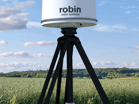
Pair with our tripod
Deploy effortlessly with our optional IRIS tripod. Set up securely at any site in minutes, with an adjustable height of 1.35 m to 2.40 m.